Rafting
If you want to raft on a gorgeous wilderness river, check out the Middle Fork American River. Placer County Water Agency facilities provide excellent rafting access on the Middle Fork for experienced and novice rafting enthusiasts alike.
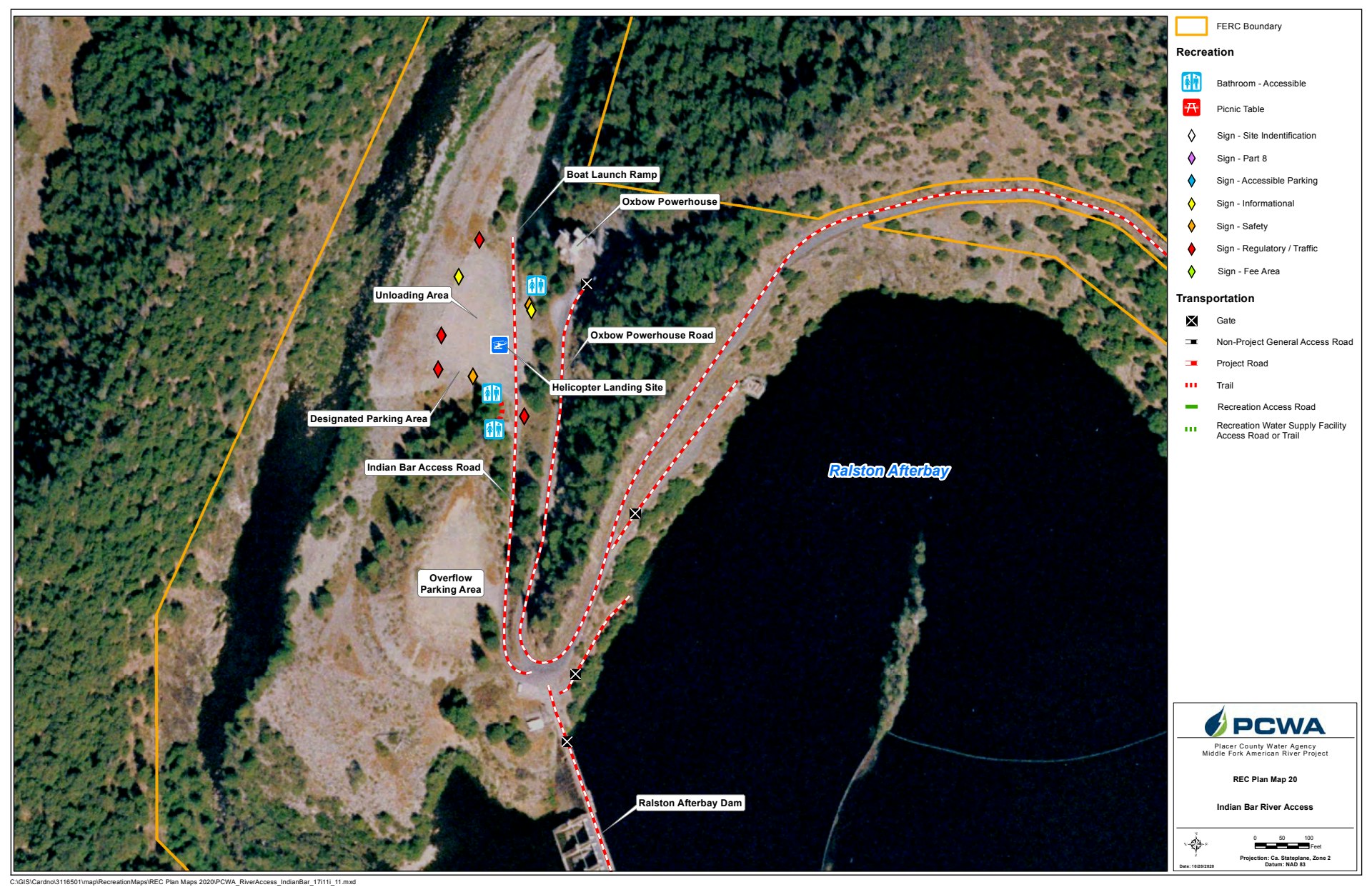
The Indian Bar rafting access and parking area near Oxbow Powerhouse supports whitewater rafting. Several independent rafting companies provide opportunities for rafting at any level. Please follow their safety rules and regulations.
Placer County Water Agency releases flows for an additional four days during the recreation season for a Class II rafting run. This is a Class II-level trip with straightforward rapids and wide, clear channels to navigate. Beginning at the confluence of the North and Middle Forks of the American River, this rafting run is calmer than our other more advanced-level trips and ideal for beginner and novice boaters.
The Class IV run is a more advanced 15-mile run that puts in at the Indian Bar access at Oxbow Powerhouse. These more powerful, but predictable rapids require more precise boat handling in turbulent water and is an exhilarating adventure with gorgeous scenery.
The current water year has been designated as below normal based on the Department of Water Resources Bulletin 120 May forecast (May 1, 2025). For more information on recreational flow releases and schedule see our Water Year Type page.
Scheduled Weekday Class IV Run Recreation Flow Releases
| Water Year Type | Flow Magnitude (cfs) 1 | Timing | June - Labor Day | After Labor Day - Sept 30 |
|---|---|---|---|---|
| Wet | 1000 | 3 hrs (9 am - 12 pm) | 5 (M, T, W, Th, F) | 4 (T, W, Th, F |
| Above Normal | 1000 | 3 hrs (9 am - 12 pm) | 5 (M, T, W, Th, F) | 3 (T, W, F) |
| Below Normal | 1000 | 3 hrs (9 am - 12 pm) | 4 (T, W, Th, F) | 3 (T, W, F) |
| Dry | 1000 | 3 hrs (8 am - 11 am) | 3 (T, W, F) except for Friday before Labor Day and Memorial Day2 | 2 (W, F) |
| Critical | 1000 | 3 hrs (8 am - 11 am) | 2 (W, F) except for Memorial Day2 | -- |
| Extreme Critical | 1000 | 3 hrs (8 am - 11 am) | 1 (W) | -- |
Scheduled Weekend Class IV Run Recreation Flow Releases
| Water Year Type | Flow Magnitude (cfs) 1 | Timing | Saturday before Memorial Day - Labor Day | After Labor Day - Sept 30 |
|---|---|---|---|---|
| Wet | 1000 | 4 hrs (8 am - 12 pm) | Saturdays & Sundays | Saturdays & Sundays |
| Above Normal | 1000 | 4 hrs (8 am - 12 pm) | Saturdays & Sundays | Saturdays & Sundays |
| Below Normal | 1000 | 4 hrs (8 am - 12 pm) | Saturdays (except for Western States 100 and Tevis Cup Race Days) & Sundays | Saturdays & Sundays |
| Dry | 1000 | 3 hrs (8:30 am - 11:30 am) | Saturdays (except for Western States 100 and Tevis Cup Race Days) & Sundays (except one Sunday in July)2 | Saturdays & Sundays |
| Critical | 1000 | 3 hrs (8:30 am - 11:30 am) | Saturdays (except for Western States 100 and Tevis Cup Race Days) & Sundays (except one Sunday in July)2 | Saturdays |
| Extreme Critical | 1000 | 3 hrs (8:30 am - 11:30 am) | Saturdays (except for Western States 100 and Tevis Cup Race Days) | -- |
Scheduled Class II Run (Confluence) Recreation Flow Releases
| Weekdays | Weekends | |||||
|---|---|---|---|---|---|---|
| Water Year Type | Flow Magnitude (cfs) 1 | Timing | Memorial Day - Labor Day | Saturday before Memorial Day - June 30 | July 1 - Labor Day | After Labor Day - Sept 30 |
| Wet | 800 | 5 hrs (3 am - 8 am) | -- | -- | Saturdays | 2 Saturdays per month |
| Above Normal | 800 | 5 hrs (3 am - 8 am) | -- | -- | Saturdays | 2 Saturdays per month |
| Below Normal | 800 | 4 hrs (4 am - 8 am) | -- | 2 Saturdays per Month | 2 Saturdays per Month | 1 Saturday per month |
| Dry | 1000 | 3 hrs (4 am - 7 am) | Memorial Day and Friday before Labor Day | Western States 100 Race Day | 1 Sunday in July and Tevis Cup Race Day | -- |
| Critical | 1000 | 3 hrs (4 am - 7 am) | Memorial Day | Western States 100 Race Day | 1 Sunday in July and Tevis Cup Race Day | -- |
| Extreme Critical | 1000 | 3 hrs (4 am - 7 am) | -- | Western States 100 Race Day | Tevis Cup Race Day | -- |
Useful Rafting Links
Maps
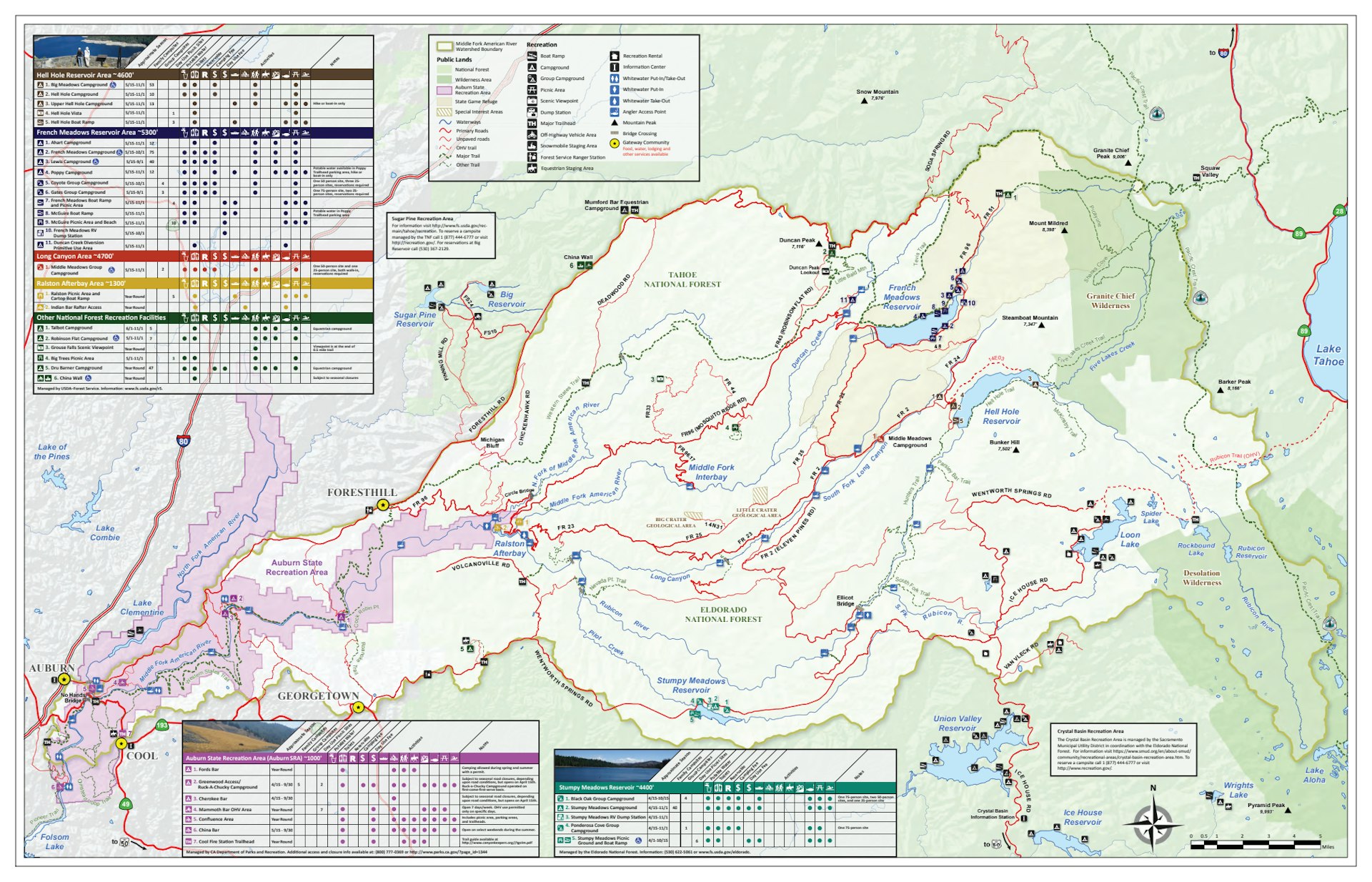
Middle Fork Project Recreation Brochure Map
Indian Bar River Access


